VANCOUVER, Wash. — Unusually heavy rain and a melting snowpack have pushed the Columbia River to near flood stage from Vancouver to Longview, according to the National Weather Service (NWS).
Forecasters issued a flood watch early Sunday for areas along the Columbia in the greater Vancouver and Portland metro areas, as well as along the lower Columbia and Interstate 5 corridor in Cowlitz County, the Columbian reported.
As of noon Sunday, the river had risen to 15.56 feet in Vancouver and covered a portion of the Waterfront Renaissance Trail.
The rising river levels follow an unusually wet stretch of weather fueled by an atmospheric river of subtropical moisture, which brought 1.44 inches (3.65 centimeters) of rain to Vancouver’s Pearson Field in a 48-hour period ending Saturday evening.
Flood stage in Vancouver is 16 feet (4.87 meters), and the river had reached 16.06 feet near the Interstate Bridge by late Monday afternoon, according to the National Oceanic and Atmospheric Administration's Northwest River Forecast Center.
At 16 feet, minor flooding occurs, affecting islands and low-lying areas, with minor impacts on parks or trails along the river, according to the National Weather Service.
Officials at the Multnomah County Drainage District, which maintains levees and pump stations to reduce the risk of flooding on the Columbia River and Columbia Slough near Portland, announced on Monday that staff had begun "enhanced operations" over the weekend to closely monitor and inspect the infrastructure.
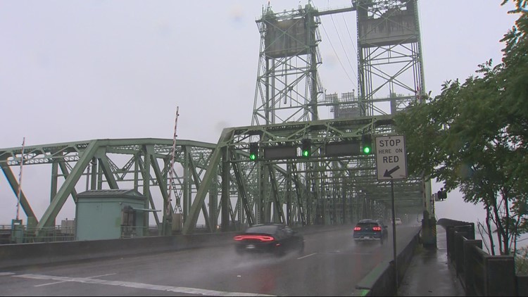
The Interstate Bridge has been experiencing more frequent lifts in the past several days because the higher river level has reduced the available clearance for vessels passing beneath the bridge.
Multiple rivers rising
The Willamette River has also risen substantially in recent days, and Multnomah County officials warned Portland residents on Monday to expect more frequent lifts of the Broadway, Burnside, Morrison and Hawthorne bridges due to decreased clearance.
The bridges have been bumped up to 24/7 staffing due to the high demand for lifts, the county said, and will remain at that staffing level through at least Sunday.
Portland Parks & Recreation also had to temporarily close the floating portions of the Eastbank Esplanade over the weekend because the river was projected to rise high enough to create "unsuitable angles" for the connecting ramps.
The heavy rain also caused a combined sewer overflow event on Saturday, depositing about 344 gallons of combined sewage and stormwater into the Willamette River just north of Willamette Park, the Portland Bureau of Environmental Services reported on Monday.
The overflow outlet was not part of the Big Pipe System, according to the bureau, and that system has not overflowed in the past week despite the record rain. The city's online tracker shows the system stopped just short of hitting 100% capacity early Saturday morning.
The Multnomah County Sheriff's office also warned residents over the weekend to stay away from local rivers, particularly the Sandy River, because of fast currents and debris hazards.
The first two weeks of June have extended one of the wettest springs that the Portland region has seen in years. Portland International Airport had received 12.23 inches of rain so far this month as of June 11, according to the NWS, breaking the previous record of 11.87 inches from 2010.
The NWS also reported that this year's combined April-May-June period is already the wettest on record since 1940, even with more than two weeks still left in the month.