
PORTLAND, Ore. — The Portland region has seen one of the coldest, wettest Aprils on record so far but this week may finally bring a break to the gloomy weather. The Northwest could see the warmest temperatures in six months.
Tuesday, April 25 will be the kick-off point to a run of sunny, warmer days, including the first 70-degree day of the year on either Wednesday or Thursday.
This week's expected warm-up is long overdue. On average, the first 70-degree day is April 2, according to Portland records dating back to 1941.
The last time Portland saw a 70-degree day was October 20, 2022.
Here comes the sunshine
The area will warm up gradually at first with temperatures hovering around mid-50s over the weekend, then 60s on Tuesday, and 70s on Wednesday and Thursday. By Friday, the temperature may be warmer still. Chief Meteorologist Matt Zaffino shared this explanation:
"The graphic below shows the upper air pattern centered on Friday, April 28. If this verifies — and the computer models are showing greater and greater consistency that it will — western Oregon may very well see 80-degrees next week," Zaffino said.
"We have to get through showers on Sunday, but after that, the warming trend ramps up. If you look at this pattern with the colder green and blue bands to the west and east of the big yellow area that extends from Oregon into BC, it resembles the Greek letter Omega: Ω."

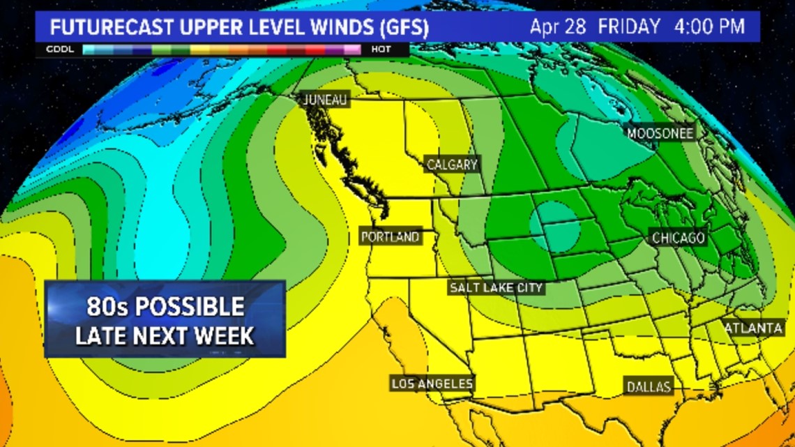
"In meteorology this is called an Omega block because usually when this pattern sets up, it sticks around for a while, blocking any storms from penetrating the middle of the omega, where the high pressure, warm air, and a generally clear sky rule. If you want warm, dry weather to stick around, omega is your letter."
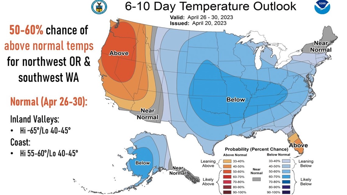
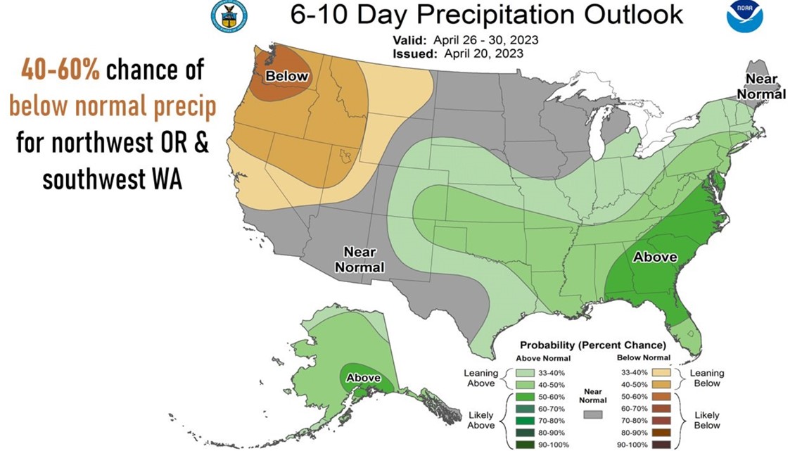
The 6 to 10 day forecasts from NOAA’s Climate Prediction Center go along with that idea. It shows a 50-60% chance of above normal temperatures from April 26 through 30 for northwest Oregon and southwest Washington. The outlook also shows below 40-60% chance of below normal precipitation for the area.


Last year, the first 80-degree day of the year for Portland didn't come until June 2. On average, the first 80-degree day is May 7.
"Despite the cold wet weather of the last several weeks, we may actually hit 80-degrees ahead of schedule this year," Zaffino said.
Cold, wet April so far
"The Pacific Northwest is no stranger to cold, wet springs but this one has been getting a little hard to take for many of us," said Zaffino. "Especially since we’ve been teased three or four times by long range forecasts advertising warm and dry weather, only to have the climatological carpet yanked out from under our soggy socks as cold, wet weather continued."

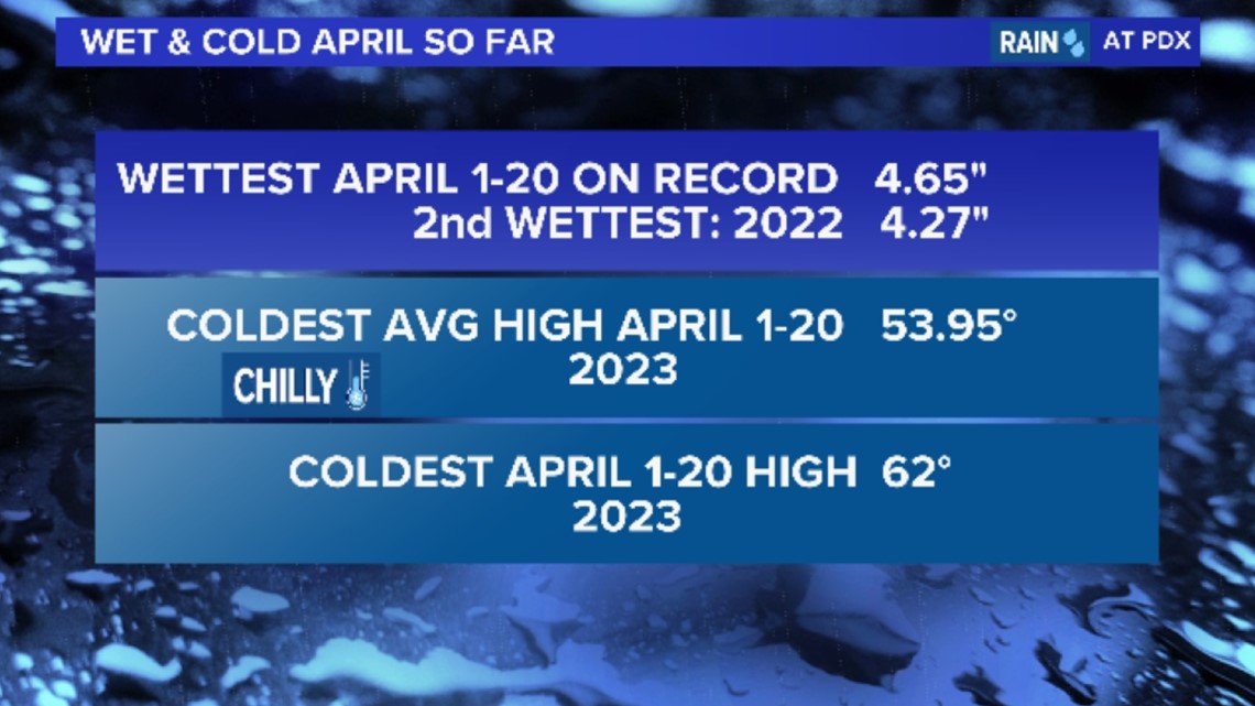
"April 2022 was the wettest April on record in Portland with 5.73 inches of rain. We’re actually on pace to beat that, but I don’t think we will," said Zaffino. "But almost no matter how you slice it, this has been the coldest and wettest first twenty days of April on record in Portland. And the story is much the same throughout the Pacific Northwest."