

SEATTLE — The Pacific Northwest typically reaches its peak snow water equivalent (SWE) in early April. The SWE is an important indicator of potential spring and summer water supply for the PNW and the West in general.
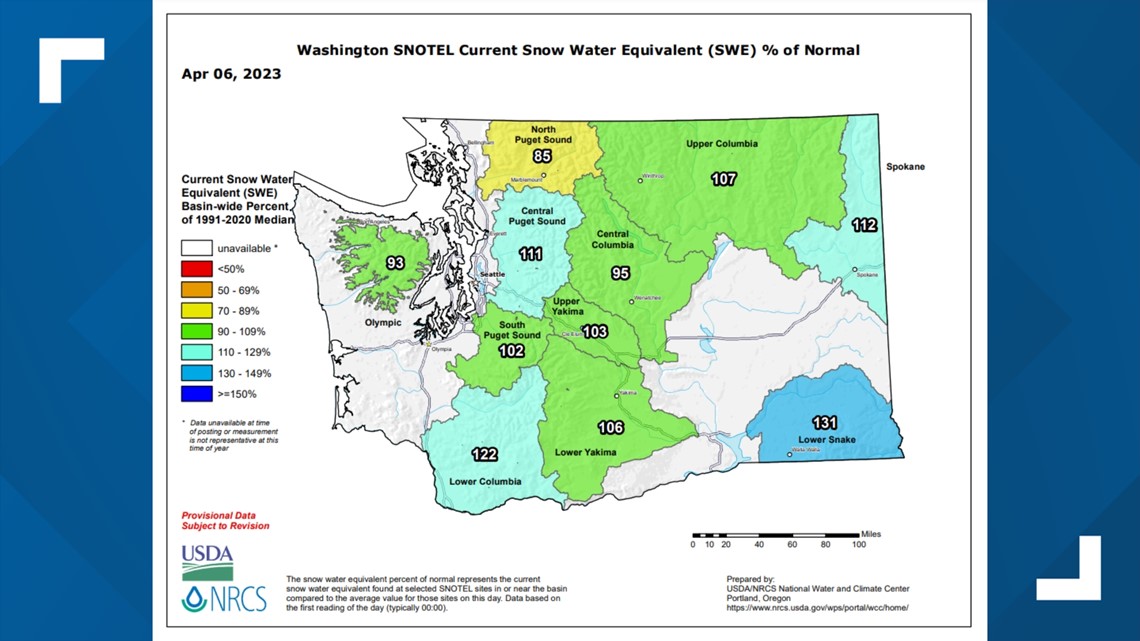
SWE can be used as a snowpack measurement—being the theoretical amount of available water depth resulting from the entirety of the snowpack melt. A look at the latest SWE, from the SNOTEL report for the state of Washington, shows the water equivalency numbers are not too far in either direction from the average. Overall, the current SWE range is from 85% of normal to 131% of normal.
Washington SNOTEL Current Snow Water Equivalent (SWE) % of Normal released Thursday, April 6

Despite the current state of SWE in the SNOTEL report, the latest National Integrated Drought Information System (NIDIS) report does suggest serious drought concerns remain for parts of the PNW due in part to a lack of snow and including the region in "snow drought."
A snow drought is what it sounds like—it is simply a lack of snow during the winter. Snow droughts are caused by either a lack of precipitation or by warmer temperatures causing precipitation to fall as rain instead of snow. In an effort to determine whether a snow drought, or low SWE values, is caused by a lack of precipitation or a lack of precipitation falling as snow (so precipitation falling as rain instead of snow), the SWE can be used in conjunction with the total winter precipitation.
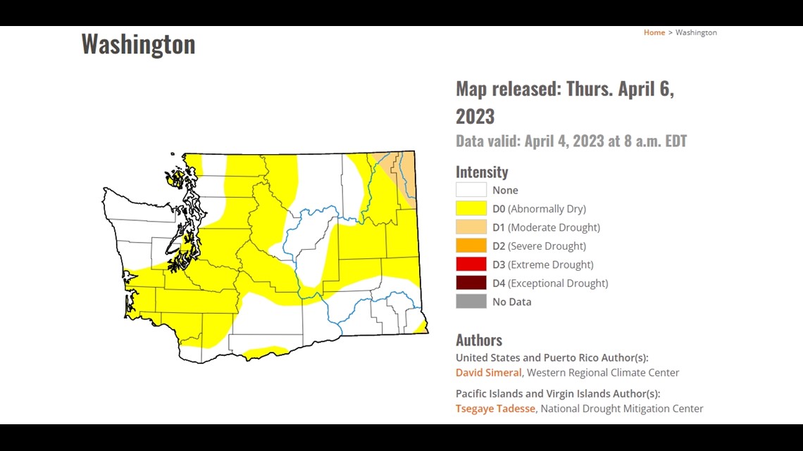
Not only is the region in a snow drought, but abnormally dry conditions have developed across parts of western Washington in the latest drought monitor. The abnormally dry conditions extend from southwestern Washington across central and south Puget Sound and across the Washington Cascade range. Abnormally dry conditions indicate an area is going into a drought and that dryness can hinder crops and increase fire danger.
U.S. Drought Monitory released Thursday, April 6

To help illustrate and quantify the abnormally dry conditions, a look at the numbers for Sea-Tac show Seattle is running nearly 6 inches (5.94 inches) below normal for the year. By April 5, Seattle typically sees 14.31 inches of precipitation. For 2023, Seattle has only received 8.37 inches.
It's even drier farther east where parts of northeastern Washington have slipped into moderate drought conditions.
Droughts and snow droughts can have lasting, detrimental impacts depending on the magnitude and duration of the drought by impacting plant and animal species, enhancing the fire season, detriments to agriculture, and has recreational and economic impacts by negatively affecting winter sports like skiing and snowboarding and late spring and summer water sports.
Mountain Snow Depth released Thursday, April 1
A quick look at the current mountain snow depth compared to normal shows many locations in the Cascades and Olympics are running slightly behind the seasonal average in the mountain snow department.
Mount Baker is sitting at 91% of normal, Snoqualmie Pass sits at 98% of normal, Stevens Pass sits at 92% of normal with Hurricane Ridge only sitting at 75% of normal. Farther south, Crystal Mountain (117% of normal) and White Pass (122% of normal) are running slightly above normal. Take a look at the latest mountain snow depth and projected snow depth for western Washington locations.
The main reason for the drier-than-normal conditions is due to the lack of atmospheric rivers this wet season for the PNW. The majority of the atmospheric rivers have impacted Oregon and California.
Despite the current snow drought, and reaching the typical peak snowpack in early April, a cooler spring can slow the typical melt rate of the snowpack and help mitigate the negative impacts of a smaller snowpack later in the warmer, drier season.