

PORTLAND, Ore. — On Monday, Portland saw its hottest day ever on record for the month of August. More triple-digit weather is expected this week, though Monday marked the peak of the current heat wave.
Both Portland International Airport (PDX) and Pearson Field Airport in Vancouver, Washington saw 108 degrees on Aug. 14. Troutdale was even hotter, climbing to 110 degrees.
"The only time we’ve ever surpassed that was during the heat dome back in 2021, which completely skewed all of our previous all-time record high temperatures," KGW meteorologist Chris McGinness said, referring to Portland's all-time high of 116 degrees in the summer of 2021.
In other words, if the 2021 heat dome had never happened, Monday would have been Portland's all-time hottest day on record. Not only did PDX break the monthly record, but it also broke the daily record of 102 set in 2008, according to the National Weather Service.
Below is a snapshot of some of the high temperatures that were recorded around Oregon on Monday.
Monday's high temperatures:
- Troutdale: 110 degrees
- PDX and Vancouver: 108 degrees
- Hillsboro and McMinnville: 107 degrees
- Salem: 105 degrees
- Astoria: 95 degrees
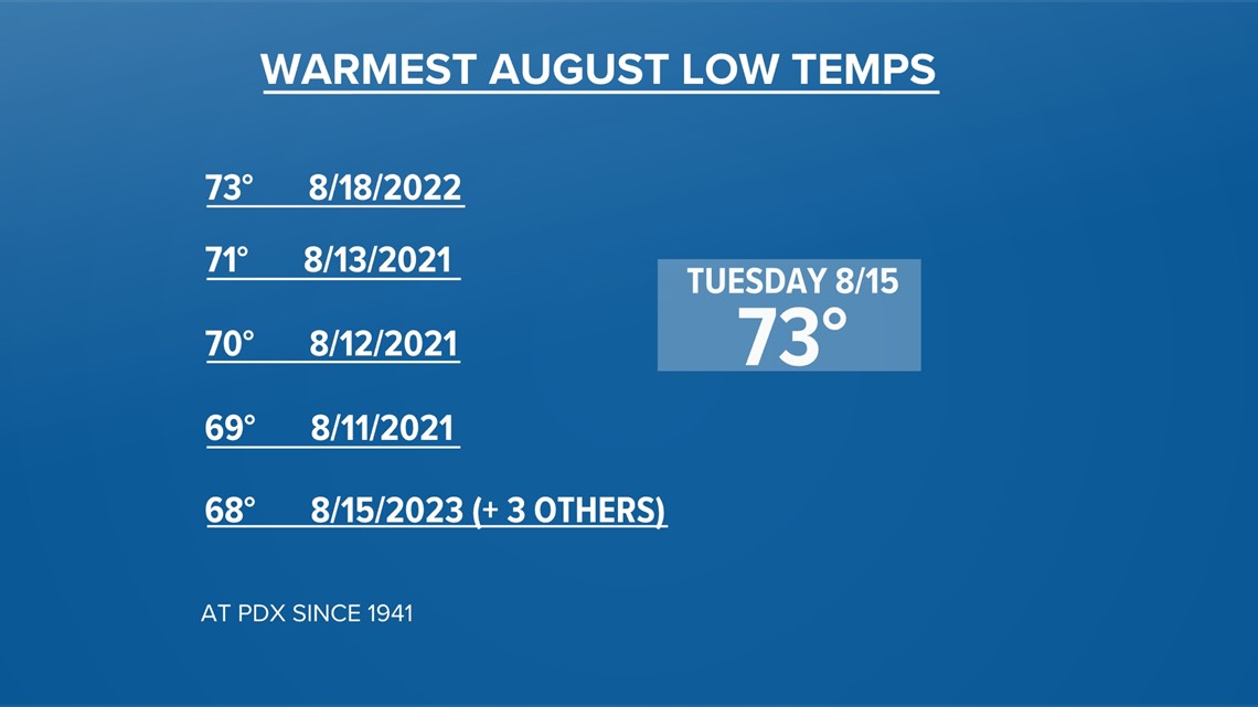
Portland saw a low temperature of 73 degrees on Tuesday morning. If that holds as the lowest temperature of the day for Tuesday, it would tie for the warmest low temperature in August on record, which was set just last year, McGinness said. He added that Monday's low of 68 degrees was a daily "warm minimum" temperature record as well.
The graphic below shows records for the warmest August low temperatures, ranging from 68-73 degrees, that were recorded between 2021 and 2023.
"So basically, the six warmest August nights on record have occurred in the last three years," he said.

Heat wave continues
Highs are expected to rise to 104 degrees on Tuesday, which would mark the third consecutive day of triple-digit weather. It could also easily break the previous high temperature record for Aug. 15, which was 100 degrees set in 2008, McGinness said. Portland could notch a fourth day of 100-degree heat on Wednesday before the heat wave is over.
“Luckily, after we get through this stretch, we don’t see that kind of heat in the next seven to 10 days," McGinness said.

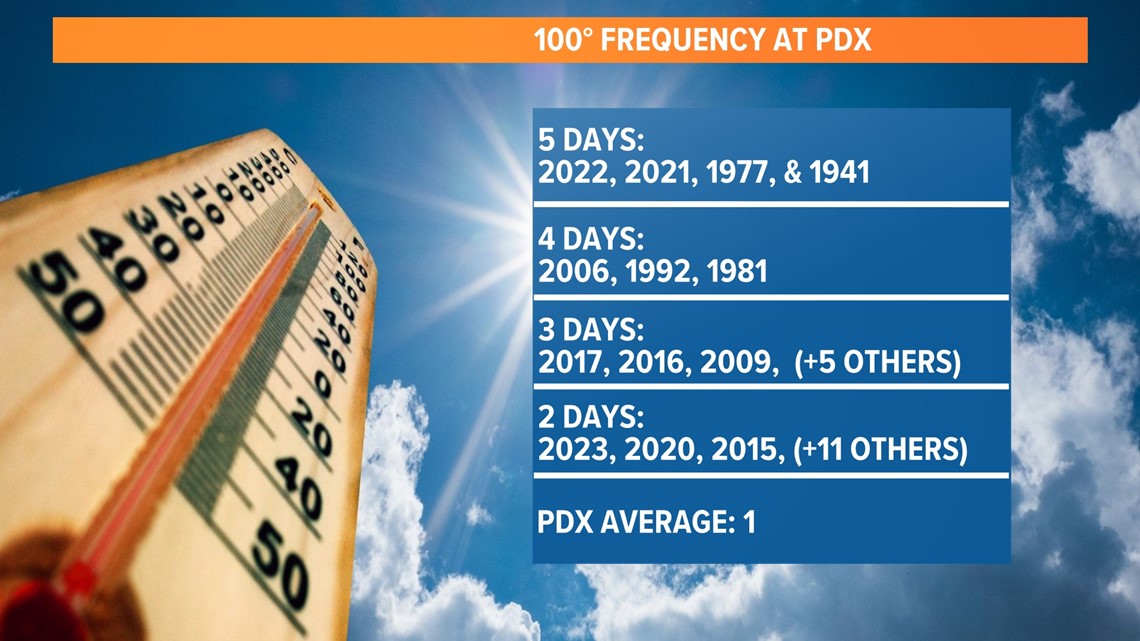
100-degree days becoming more frequent
While PDX averages one 100-degree day each year, triple-digit temperatures have been occurring with more regularity over the last three years. PDX has reached two or more days at or above 100 degrees a dozen times in the past 20 years, according to McGinness. There were five 100-degree days in both 2022 and 2021.
The current heat wave has many people wondering what role climate change is playing. On Monday night, KGW Chief Meteorologist Matt Zaffino dived into the topic on The Story.
"Just in the last two years, since 2021, we've broken our previous all-time record high temperature four times," Zaffino said.
Zaffino said that the current heat wave is five times more likely due to climate change, according to Climate Central's Climate Shift Index. Citing the research, he added that people can expect to see an increase in both the frequency and the intensity of extreme weather.