
PORTLAND, Ore. — It's going to be a cold and windy week for western Oregon, with heavy snow expected in the Cascade Mountains and along the coast. The lower elevations of the Willamette Valley, including the Portland metro area, could see snow flurries and scattered, sticking snow Tuesday night through Wednesday.
Here's a look at what the latest forecast shows and when people in the lower elevations of the Portland metro could see snow.
Heavy snow in the Cascades, coast range
Traffic cameras showed roads in the Cascade Mountains and along the coast range, including Highway 6 and Highway 26, covered in some snow Tuesday morning.
A Winter Storm Warning is in effect for the Cascades and the coast through 10 a.m. on Wednesday. Snow levels will lower to 500 feet and below.
A total of 12-24 inches of snow could fall over the Cascades and 6-12 inches over the coast range through Wednesday morning, according to KGW meteorologist Rod Hill.
Portland snow chance
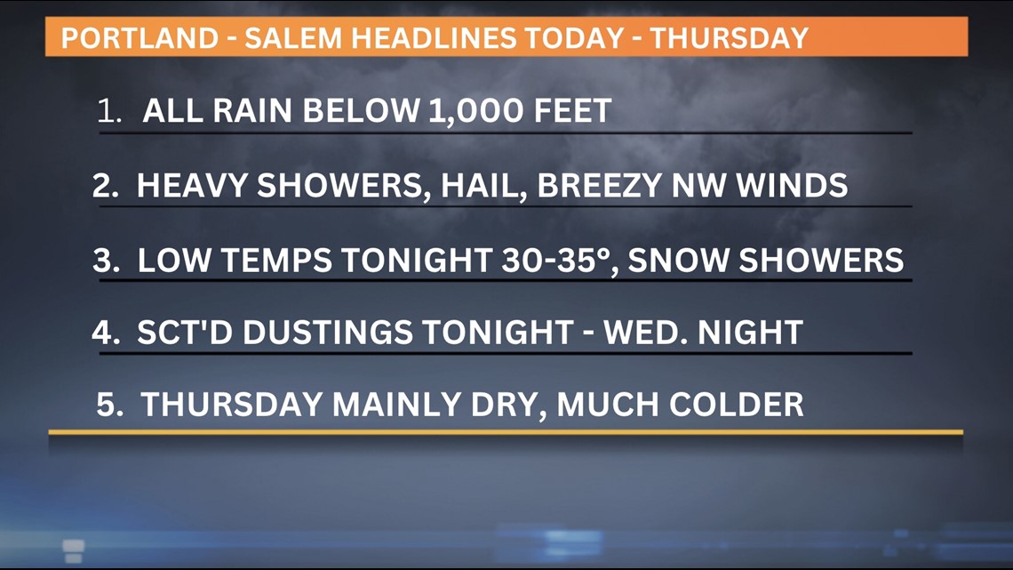
In Portland and Salem, much colder air will bring scattered, heavy showers with hail and possibly thunder on Tuesday. Elevations below 1,000 feet will only see rain, with breezy northwest winds from 15-25 mph.
Parts of the Interstate 5 corridor could see scattered dustings of snow starting Tuesday night through Wednesday night. Low temperatures in the Willamette Valley will be near freezing, with highs reaching near 40 degrees or cooler on Wednesday.
Early Wednesday morning, the west wind will blow back to the east, bringing colder air and dropping snow levels to 500 feet and lower at times. Most of the precipitation on Wednesday is expected to be snow showers, Hill said.
Thursday morning will be cold, with low temperatures in the mid 20s in the valley and gusty east winds. Dry weather could last through Saturday.

High winds
High wind advisories and warnings are in effect through Tuesday morning for central Oregon and the eastern Columbia River Gorge through Pendleton. Expect strong west wind gusts of 50-60 mph in the Columbia Basin and gusts up to 50 mph in central Oregon.
In the Cascades, Mount. Hood Meadows suspended lift operations on Monday, Feb. 20 due to high winds. The resort said lifts are open from 9 a.m. to 4 p.m. on Tuesday, but winds could affect some lift operations.
KGW Weather Links:
VIDEO PLAYLIST: KGW Weather