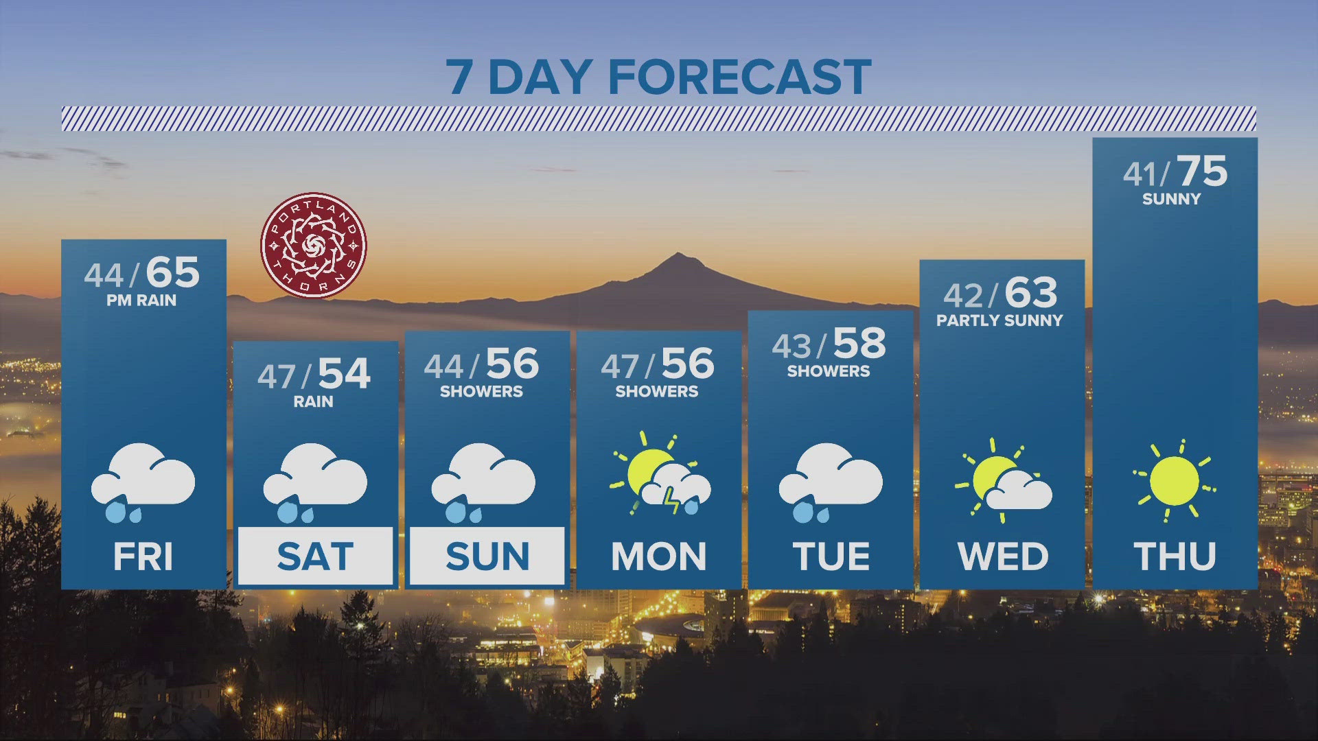
PORTLAND, Ore. — After seeing some rainfall Friday night, it’s expected to get really wet in Western Oregon and Southwest Washington the rest of the weekend.
Steady rain began falling in the Portland metro area late Saturday afternoon and is expected to continue.
“All total, 2.25 inches to 3.25 inches of rain for the I-5 corridor is expected through the day Monday,” KGW meteorologist Rod Hill said
The National Weather Service (NWS) said the heaviest rains are expected Saturday night.
“An atmospheric river will bring heavy rain to much of the area this weekend, with the heaviest rainfall expected Saturday evening through Saturday night,” NWS said. “Rain will continue for most areas Sunday through Sunday night, but will not be as heavy.”
RELATED: Check live radar now
What is an atmospheric river? KGW meteorologist Chris McGinness said it's a long narrow band of air with high water vapor content. It is responsible for much of the wet season rain and snowfall in the Pacific Northwest.
McGinness also showed a projection of when the rain is expected to impact the area.
The weather service issued a flood watch for much of Western Oregon and Southwest Washington. It went into effect Saturday afternoon and will remain in effect through Sunday evening. Landslides could be possible.
“Excessive rainfall could lead to river flooding as well as flooding of small streams and urban areas,” NWS said. “Heavy rain across the Cascades could cause debris flows over and near the recent burn areas.”

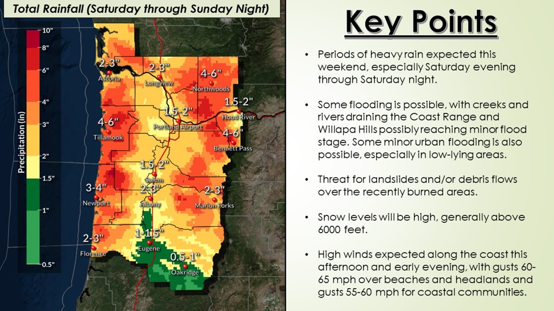
NWS singled out the following rivers with the greatest threat for minor flooding:
- Grays River in Rosburg, Wash.
- Nehalem River in Foss, Ore.
- Wilson River in Tillamook, Ore.
- Siletz River in Siletz, Ore.
- Luckiamute River near Suver, Ore.
- Tualatin River near Dilley, Ore.


In addition to the threat of floods, strong winds are expected on the Oregon and Washington coasts. A high wind warning went into effect early Saturday afternoon and remains through the night. South winds of 25-40 mph with gusts of 50-60 mph are expected. NWS warned there could be isolated tree damage and power outages.


Whether or not the floods are heavy over this weekend, the Oregon Office of Emergency Management (OEM) said now is the time to prepare for an unpredictable winter.
"With a wet, cold winter expected and burn scars prevalent from the 2020 wildfires in Oregon, it is important to be ready for flooding and landslides," said OEM spokesperson Cory Grogan. "Heavy rain can trigger mudslides and debris flows in steep terrain, and the risk is higher in wildfire burn areas."
Grogan offered the following tips for people whose homes, jobs or driving routes are in a flood watch area:
- Stay alert and track the flood watch by radio, TV, weather radio or online. If told to evacuate, do so immediately.
- Listen to unusual sounds that might indicate moving debris, such as trees cracking or boulders knocking together. A trickle of falling mud or debris may precede larger landslides. If you think there is danger of a landslide, leave immediately.
- Watch the water. If water in a stream or creek suddenly turns muddy, or if the amount of water flowing suddenly decreases or increases, this is a warning that the flow has been affected upstream. You should immediately leave the area because a debris flow may soon be coming downstream.
- Travel with extreme caution. Assume roads are not safe. Be alert when driving, especially at night. Embankments along roadsides may fail, sending rock and debris onto the road.
- Have an emergency kit ready with necessary supplies. The Oregon Office of Emergency Management recommends being 2 Weeks Ready with enough supplies to last at least two weeks. Be ready and stay safe.
For more information about what to do before, during and after a flood visit the OEM website.