PORTLAND, Ore. — After an unexpected third round of severe winter weather hit the Portland metro area Thursday, the barrage of storms that have besieged the Portland metro area for nearly a week appear to be finally coming to an end.
Three separate winter storms that brought snow, sleet, ice and high winds to the region have caused at least 10 deaths, knocked out power to thousands of people, canceled school for a week, brought down hundreds of trees, and snarled roads across much of northwest Oregon and southwest Washington.
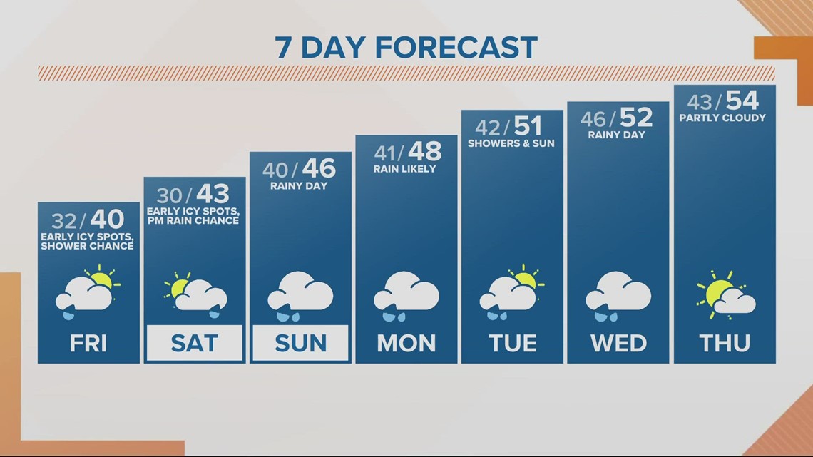
Warnings and advisories across the Portland area and out into the gorge lifted Friday morning. Temperatures will warm up into the 40s during the day, though the area may see temperatures dip below freezing Friday night, refreezing whatever thaws during the day Friday.
Uninterrupted thawing and melting will finally commence Saturday as temperatures rise into the 40s with incoming rain Saturday night that will last through Monday. Those two days of precipitation could bring as much as an inch to an inch and-a-half of rain to the Portland metro area, KGW Meteorologist Rod Hill said Friday morning.
"The next organized batch of moisture comes in Saturday evening. ... [It will be] raining more hours than not Saturday night, Sunday, Sunday night and Monday," Hill said. "This batch of rain comes with the first true warming that we will see taking us out of the grips of this cold air that we've been in."
Next week looks even better for the Portland metro area, with temperatures warming up into the low to mid-50s, Hill said.


It will take a little longer to warm up out east into the Columbia River Gorge. Hill said there could be ice or snow Saturday night before things eventually warm up sometime during the day Sunday.
"Gradually, we think the gorge will be warming and changing to rain Sunday, but not sure when that happens," Hill said. "Eventually, I think that pretty much becomes all rain, but again not sure when that happens on Sunday, so keep yourself updated for travel plans in the gorge Saturday night into Sunday."
Public transportation
TriMet's Yellow Line, between the Expo Center and Interstate/Rose Quarter, is running as of Friday evening.
TriMet's Blue Line is running through downtown as of late Friday afternoon; service is restored between Hatfield Government Center and Northeast 7th Avenue, except for Washington Park. MAX Blue Line service has been extended to serve stations between Hatfield Government Center and Rose Quarter Transit Center, TriMet said.
Meanwhile, shuttle buses are serving between Northeast 7th Avenue and Gresham.
Closures
Tualatin Hills Parks and Recreation said all buildings will be closed this weekend to "focus on essential storm recovery work" until Monday. Portland Parks and Recreation is also closed until Monday.
Portland Community Colleges remain closed to all in-person classes and activities.
Lake Oswego School District said Friday that all activities, practices and events are canceled through Sunday.
Multnomah Falls Lodge is currently closed until further notice due to flooding.
Columbia River Highway will likely remain closed through the weekend due to debris and ice, according to the Oregon Department of Transportation (ODOT).
U.S. Highway 12 White Pass reopened Friday morning.
Several roads in east and west Multnomah County were closed Friday morning due to icy conditions, downed trees and power lines.
Download the KGW News app: Download for iPhone here | Download for Android here
Stream newscasts for free on KGW+ on Roku and Amazon Fire: How to add app to your device here
See a typo in this article? Email web@kgw.com for corrections.

