
PORTLAND, Ore. — Parts of the Portland metro area got hit with an extra dose of freezing rain Thursday, but the impact appeared to be limited as of late afternoon. Most of the main roads were already clear Thursday morning, with ice persisting on side roads.
It didn't get quite cold enough for a new layer of ice to form on the main roads, according to KGW chief meteorologist Matt Zaffino, but it was enough to keep many side roads icy throughout the day.
"It's kind of like taking a frozen turkey and putting it in your refrigerator — takes a long time for that to thaw out, right?" he said.
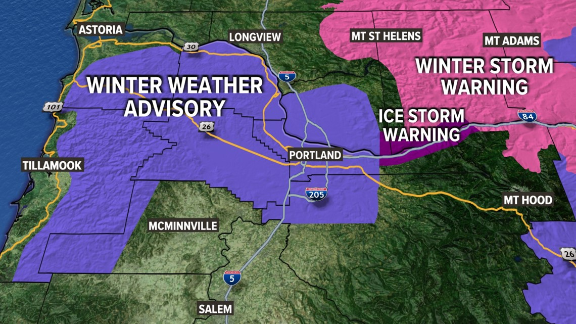
The National Weather Service (NWS) issued a new ice storm warning for the western Columbia River Gorge Thursday morning, warning of high winds and the potential for new ice and snow accumulation. Some of that cold air was expected to spill over into the metro area, prompting a winter weather advisory for the region, and officials advised Portland residents to continue to stay off the roads during the day.
This new weather threat comes as Portland continues to deal with the impact of nearly a week of severe winter weather that's led to at least 10 deaths, knocked out power for hundreds of thousands of people, brought down hundreds of trees and snarled roads across the Portland and Vancouver metro area.
There is also a winter storm warning in the central and east Gorge that calls for 5-10 inches of snow. Snow levels over the Cascades will hold above Government Camp at 4,000 feet.

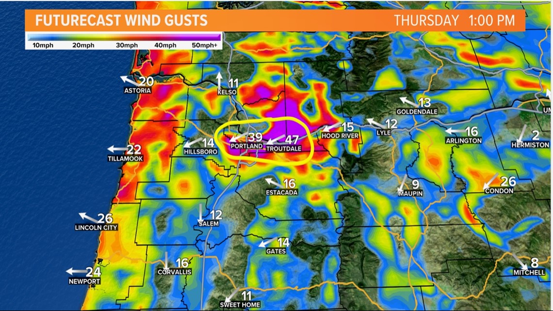
KGW Meteorologist Rod Hill said east winds out of the Columbia River Gorge increased Thursday morning, causing temperatures in the eastern metro area to start to drop. Weather model guidance began to show that much of the Portland metro area could fall to freezing temperatures or below, especially into the afternoon hours Thursday.
"Plenty of moisture is available with steady rain falling across the area [Thursday] morning. Areas that refreeze could see significant icing," Hill said Thursday morning. "Best bet at this moment is to cancel today's plans and stay home or go home to play it safe. If temperatures fall off, roads will see new icing."
Both Troutdale and Gresham are reporting freezing rain Thursday morning, Hill said, and Portland was fluctuating between 32 and 34 degrees leading up to midday.
"Thursday will be a close call [in the Portland metro area] with temperatures ... either just below 32 degrees with freezing rain much of [Thursday] or holding at 33-35 degrees with rain," Hill said.
Temperatures had warmed up a bit by the later afternoon, Zaffino said, with Portland International Airport reporting 35 degrees, although it wasn't uniform, with Happy Valley seeing 28 degrees.
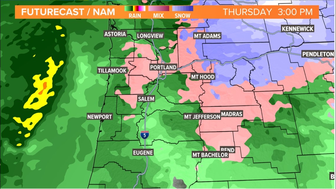
Hill shared a couple weather graphics (see below) to illustrate the threat: A future forecast shows strong winds from the east blowing cold air across the north valley at 1 p.m. Thursday and freezing rain in Portland and across Washington County at 3 p.m. "The salmon color is freezing rain; the blue is snow in the gorge," Hill explained.


The Portland Bureau of Transportation (PBOT) reported Thursday at around 8 a.m. that the National Weather Service (NWS) told them that "more freezing rain could be on the way, beginning as early as 10 a.m., with the best chances of accumulating after 4 p.m."
"Avoid unnecessary travel," PBOT said. "Be prepared for worse conditions than expected, as forecasts come with uncertainty about timing and amounts of freezing rain."
Things look like they'll finally start to improve in the metro area Friday, with drier weather, slightly warmer temperatures and a chance of rain showers. Warmer winds blow in over the weekend, pushing temperatures up in the 40s. Next week, Portland will see a return to 50-degree highs.
"Confidence is very high that we'll get back into the same type of weather pattern we had back in December," Hill said. "I'm talking about temperatures well up into the 50s by midweek next week and lasting for quite some time, it appears."
This is a developing story and will be updated.