

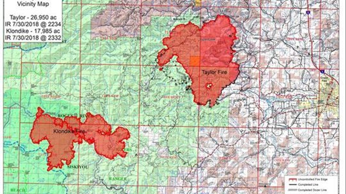
The Taylor Creek Fire burning west of Grants Pass continued to wreak havoc, even as fire teams made progress in containing Oregon’s most dangerous blaze.
The fire was almost 30,000 acres Wednesday morning and has burned all the way down to the Rogue River on the fire’s northern flank. That brought new evacuations and kept the iconic river closed to boats for a 7 to 8 mile stretch.
At the same time, fire teams made solid progress on the fire's southeastern flank, bringing containment on the fire up to 30 percent and allowing almost 400 people to return to their homes.
That leaves around 600 to 700 people who’ve been evacuated from their homes due to the fire, officials said.
“We’re feeling pretty good about our fire lines in the Limpy Creek area, and that’s allowed us to bring down some of the evacuation levels,” fire spokesman Joel Brumm said Wednesday morning.
The main fight is focused on the fire’s northern flank along the Rogue River between Merlin and Galice. The stream known worldwide for its rafting has become a critical barrier, as firefighters do everything they can to keep the flames from leaping the river.
“The fire has not spotted across the river yet and we want to keep it that way,” Brumm said. “We did a lot of burn-out operations yesterday, using lower-intensity fire to take the wind out of the fire’s sail as it rolled down the hill. That gives it less fuel to send embers over the river.
“But we also have fire teams ready to put out any spot fire that does cross the river.”
After days of miserable firefighting conditions — triple digit temperatures — the weather appears to be heading in a more helpful direction.
“We’re expecting it to get a few degrees cooler, so that’s going to help,” Brumm said. “We were facing multiple days of red flag conditions earlier this week.”
The most up-to-date information on evacuation levels can be found on this map or by calling 541-474-5305.
The Rogue River is closed from Hog Creek Boat Ramp to Galice, which represents about 7 to 8 river miles, including the stretch though popular Hellgate Canyon. However, the vast majority of the river remains open — see this post for more details.
Taylor Creek is the largest of the fires to have grown out of a lightning storm earlier this month, but there remain eight large wildfires and multi-fire complexes burning in the area that have impacted air quality across southwest Oregon.
For details on evacuation levels — as they change — follow the Josephine County Sheriff's Office.
For the most current map and evacuation areas, see this page.
Below is an update on all of the major fires in Southern Oregon.
Klondike Fire (evacuations near Selma and Illinois River)
The wildfire burning on the east side of the Kalmiopsis Wilderness, known as the Klondike Fire, continued to grow this weekend. As of Wednesday morning, the fire has burned 17,987 acres with just 5 percent containment.
The fire has spread out of the wilderness and fire teams are primarily looking at how to stop the blaze from moving east toward Selma.
"Our primary focus is protecting values along the Illinois River Road and developing good fire lines to protect the U.S. Highway 199 corridor and towns such as Selma," Noel Livingstone said in a morning briefing Monday.
Firefighters prepped forest roads and old Biscuit Fire fire lines to control fire to north and east. Heavy smoke kept air operations to a minimum.

A level 3 'Go' evacuation order remains in effect for the Oak Flat area on Illinois River Road. Illinois River Road from mile post 2.5 to Oak Flat is at a level 2 evacuation level meaning “get ready.”
In addition, a number of trails, including the Illinois River Trail, have been closed.
In an update Tuesday, fire officials said the air mass over the fire is seeing a very gradual cooling trend. Anticipated increases in humidity over the next several days could dampen fire activity and smoke emissions, but poor air quality continues to persist in communities near the fire.
Natchez Fire (closures near Siskiyou Wilderness)
The Natchez Fire, located 15 miles south of Cave Junction, showed more growth earlier this week.
The fire grew to 6,174 acres as of Tuesday evening and is continuing to spread on the north and south ends of the fire.
Crews worked to connect Forest Service roads using low-intensity burn outs on the north side Monday.
By the end of the day, firefighters had managed to increase containment from 10 percent to 15 percent.
The community of Sunstar has been placed in a level 1 evacuation “get ready” status.
Fire closures are in place in both the Klamath National Forest and the Rouge River-Siskiyou National Forest.
South Umpqua Complex (evacuation warnings near Tiller)
This complex of three larger wildfires and numerous smaller ones grew to 16,428 acres as of Wednesday with 16 percent containment.
The Miles Fire, now top priority in the South Umpqua Complex, continued to push east toward Hawk Mountain. Multiple spot fires were sparked by wind-blown embers near the southeast perimeter. The fire has covered 4,605 acres with 14 percent containment.
Crews were shifted away from the Snowshoe Fire, covering 3,816 acres with 95 percent containment, where personnel were mopping up and searching for hot spots.
Wind gusts carried embers sparking multiple spot fires half a mile out of the Columbus Fire southern edge, according to reports. The fire has covered 5,703 acres. After days of zero containment, the blaze is now 5 percent contained.
Crews installed sprinklers around the world's largest sugar pine, located in the Umpqua National Forest about 20 miles east of Tiller, for protection from the Columbus Fire.
Heavy smoke is expected in the area, and officials warn an unstable atmosphere could lead to "extreme fire activity."
Closures remain for a campground and roads in the Tiller Ranger District.
For more details on the South Umpqua Complex, including more details on closures, click here.
Sugar Pine fires
The 19 small- to medium-sized wildfires burning north of Prospect and Tiller on either side of Oregon Highway 62 south of Crater Lake continue to spread.
Collectively they have burned more than 6,086 acres as of Tuesday night.
Sustained high temperatures, gusty afternoon winds and low humidity have continued to fan the flames.
The Sugar Pine Fire grew by hundreds over acres since the weekend, covering a total of 4,172 acres and remaining zero percent contained. The Goodview Fire continued to grow to 1,630 acres and is also zero percent contained.
Northwest winds, temperatures nearing 90 and increased airflow as the shroud of smoke clears could increase fire activity, officials said.
An Level 2 evacuation order set for the Elk Creek area was elevated to a Level 3 "Go" evacuation Tuesday night.
Sheriff's officials said residents "should not delay leaving to gather any belongings or make further efforts to protect your home. This may be the last notice you receive."
Deputies and search and rescue volunteers will deliver notices to in person, but residents do not need to wait for a notice to vacate their homes.
More information about the evacuation is available here.
Firefighters worked on improving multiple fire lines north of homes by setting up hoses and sprinklers and moving flammable items away from houses.
Fire personnel numbering over 840 remain assigned to the fire.
Other active fires in the area include:
Round Top — 154 acres, 48 percent contained
Union — 106 acres, 6 percent contained
The report states that all other fires on the north end of the High Cascades Ranger District have been contained.
For more information, visit this page.
Grave Creek / Pleasant Creek fires (evacuations near Wimer)
Crews battling flames in the Grave Creek and Pleasant Creek fires burning near Wimer were able to slow growth this weekend. The fires are part of the 8,886-acre Garner Complex Fire.
With teams working to secure perimeters and smoke from the Klondike Fire helping drop temperatures, the complex was 65 percent contained as of Tuesday evening.
Fire teams have the Pleasant Creek Fire at 835 acres, a slight shrinkage since Saturday.
The Grave Creek Fire reversed its growth pattern and shrank by a few acres, making it a total of 7,816 acres.
Despite the positive news, officials are remaining cautious.
"While the threat to homes on the Garner Complex has diminished, evacuations remain in place for the safety of the residences and fire crews," officials said in an update Monday night.
More than 2,600 personnel are battling the flames. Crews are mopping up areas, working with infrared cameras to spot pockets of heat and flying over the region to monitor the flames.
“Very impressive work so far, we need to keep making progress," said John Flannigan, Day Shift Operations Section Chief. "With the potential for new fire starts to grow rapidly, crews have been notified that they have initial attack responsibility to help the local district."
For detailed information, click here.
Hendrix Fire (evacuation warnings near Ruch)
The Hendrix Fire southwest of Ashland, in the Little Applegate River area, remains at 1,082 acres and is now 70 percent contained as of Tuesday.
The southeast corner remains without a firm containment line due the to steep, challenging terrain, according to officials. Crews are scouting the area for opportunities to fully suppress the blaze.
A helicopter and 267 personnel are assigned to the blaze.
Officials moved back the expected containment date to the end of August due to the lack of containment lines on the southeast corner.
A portion of the Pacific Crest Trail closed by the fire has been reopened.