

MIAMI — MIAMI (AP) — The Latest on Hurricane Dorian (all times local):
4 p.m.
Authorities in the Bahamas are saying they are receiving preliminary reports of heavy damages in areas being pounded by Hurricane Dorian.
Joy Jibrilu, director general of the Bahamas' Ministry of Tourism & Aviation, has told reporters there is a huge amount of damage to property and infrastructure from the hurricane crossing the northwest part of the island archipelago. She adds "It's devastating" but cautions that so far there is "luckily no loss of life reported."
Video that was described by Jibrilu as being sent by residents from the island of Abaco on Sunday afternoon showed homes with missing chunks of roofing, downed power lines and smashed and overturned cars. One video, she says, showed floodwaters rushing through the streets of an unidentified town at nearly the height of a car's roof.
At 3 p.m. EDT Sunday, Dorian had top sustained winds of 185 mph (295 kph) with gusts topping 220 mph (above 350 kph), according to the U.S. National Hurricane Center in Miami.
___
3:35 p.m.
The U.S. Coast Guard says it helped the Brevard County Sheriff's Office rescue two people after a wave knocked them off a boat near the Florida coast as Hurricane Dorian churned in waters to the east.
The Coast Guard said in a news release that it received a call from the Indian River Police Department on Sunday that people were in the water near Sebastian Inlet. It launched a vessel and a helicopter to search the area.
The sheriff's office pulled one of the boaters from the water and confirmed the other was safe.
The Latest: Bahamas official on Dorian: 'It's devastating'


___
3:40 p.m.
North Carolina elections officials are encouraging voters in some pending congressional races to cast ballots during an early-voting period to avoid possible disruptions from Hurricane Dorian.
The state Board of Elections says the early voting period for the Sept. 10 elections ends on Friday. Races on the ballot include elections for the 3rd and 9th congressional districts. The 3rd congressional district includes most of the eastern coast of North Carolina. Most early voting locations are closed for Labor Day, but are to be open Tuesday through Friday.
The state's emergency management director, Michael Sprayberry, said at a news conference Sunday that North Carolina could begin feeling Dorian's effects as early as Wednesday night. Gov. Roy Cooper says the state is likely to see heavy rains, winds and flooding from Dorian even if the storm weakens as it churns closer to the state.
____
3:20 p.m.
President Donald Trump is urging everyone in Dorian's potential path to obey all warnings and evacuation orders from local authorities, saying public safety "must always come first."
Trump said Sunday that he and members of his staff are receiving frequent updates on the "monstrous" storm "to ensure that we are fully prepared. And we are fully prepared."
Speaking in Washington at the headquarters of the Federal Emergency Management Agency, where he was updated on the storm's path, Trump said the slow-moving hurricane is one of the largest to ever materialize. He says the expectation is that a large part of the Eastern seaboard will be affected, "some of it very, very severely."
The Hurricane Center said Dorian's maximum sustained winds stood Sunday at a monstrous 185 mph (295 kph), with higher gusts. Dorian is located about 185 miles (295 kilometers) east of West Palm Beach, Florida.
Trump later tweeted: "Pray for the people in the Bahamas. Being hit like never before, Category 5. Almost 200 MPH winds."
___
3:05 p.m.
Forecasters say "catastrophic" Category 5 Hurricane Dorian is continuing to batter Great Abaco island in the Bahamas.
The U.S. National Hurricane Center is describing the pounding the northwest Bahamas as a "life-threatening situation" and urged residents not to venture out into Dorian's well-defined eye should it pass overhead.
At 3 p.m. EDT Sunday, Dorian had top sustained winds of 185 mph (295 kph) with gusts topping 220 mph (above 350 kph). The Miami-based hurricane center says it expects storm surge of 18 to 23 feet (5.4 meters to 7 meters) above normal in the hardest-hit areas. It says there also will be even higher battering waves.
Forecasters warn that Dorian is moving so slowly westward __ at 7 mph (11 kph) __ that those in the affected areas of the Bahmas will continue to receive a pounding from Dorian's wind and surging seas for several more hours.
____
2:15 p.m.
The National Hurricane Center in Miami says Dorian made a second landfall at 2 p.m. on Great Abaco Island near Marsh Harbour at 185 mph (285 kph).
The center says that is tied for the strongest Atlantic hurricane landfall on record with the 1935 Labor Day hurricane.
The Hurricane Center said Dorian's maximum sustained winds stood at a monstrous 185 mph (295 kph), with higher gusts. Dorian is moving west at 7 mph (11 kph).
The storm's center is about 185 miles (295 kilometers) east of West Palm Beach, Florida. A Hurricane watch is in effect for Florida from the north of Deerfield Beach to the Volusia-Brevard county line. Hurricane conditions are possible within the watch area by late Monday or early Tuesday.
___
1:10 p.m.
Extremely powerful, life-threatening Hurricane Dorian has reached the Bahamas. The National Hurricane Center in Miami said Sunday that Dorian made landfall in Elbow Cay at 12:40 p.m. EDT.
Maximum sustained winds have increased to a monstrous 185 mph (295 kph) from 180 mph (285 kph).
The Category 5 storm was moving west at 8 mph (13 kph).
The Hurricane Center says the arrival of the storm poses "a life-threatening situation" with hazards that will cause "extreme destruction."
Wind gusts were clocked at over 220 mph (354 kph). The storm surge was measured at between 18 to 23 feet (5.4 to 7 meters) above normal tide levels.
___
11:30 a.m.
Officials at Florida's busiest airport say they are rescinding plans to close on Monday.
Orlando International Airport officials said late Saturday that the airport will remain open Monday because of the turn northward in Hurricane Dorian's projected path.
The airport originally had planned to stop commercial flights at 2 a .m. Monday for passenger safety and to give the airport's 25,000 workers enough time to secure their homes and be with their families.
The airport had 47.7 million passengers travel through it last year.
___
11 a.m.
The National Hurricane Center says the northwest Bahamas is facing its strongest hurricane in modern times as Hurricane Dorian's maximum sustained winds reach a monstrous 180 mph (285 kph).
The Category 5 storm has also grown in size, with hurricane-force winds extending outward up to 45 miles (75 kilometers) from its center, located about 20 miles (30 kilometers) east-northeast of Great Abaco Island.
Dorian is moving west at 7 mph (11 kph) and is expected to slow in the next day or two, potentially prolonging the Bahamas' weather misery.
The Hurricane Center said in its 11 a.m. EDT advisory that Dorian was strafing the Abacos Islands with life-threatening storm surge, destructive waves, and extremely powerful winds. Those conditions were expected to reach Grand Bahama Island later Sunday.
The hurricane was expected to move toward the Florida east coast late Monday through Tuesday. The Hurricane Center also issued a hurricane watch and storm surge watch for the east coast of Florida from north of Deerfield Beach to the line between Volusia and Brevard counties.
___
10:15 a.m.
A coastal Florida county is ordering an evacuation of barrier islands, mobile homes and areas that are prone to flood because of Hurricane Dorian.
Palm Beach County issued the evacuation order beginning 1 p.m. Sunday after the county that includes West Palm Beach was placed under a tropical storm warning.
The official forecast path for Dorian curves the storm away from the area before it strikes land.
But the National Hurricane center says there are variables that could alter that path, and there is about a 50% chance West Palm Beach will get hurricane winds by early Wednesday.
___
9:45 a.m.
Potentially devastating winds from Hurricane Dorian have strengthened yet again as the storm nears the Bahamas.
The National Hurricane Center in Miami said Sunday that maximum sustained winds have increased to 175 mph (280 kph) from 160 mph (260 kph) as it approaches Great Abaco Island. It is moving west at 8 mph (13 kph).
The center said at 9:30 a.m. EDT that the Category 5 storm is 25 miles (40 kilometers) east-northeast of Great Abaco Island and about 210 miles (340 kilometers) east of West Palm Beach, Florida.
The Hurricane Center is warning of potentially devastating wind gusts of more than 200 mph (321 kph) and destructive waves of up to 20 feet (6 meters).
"These hazards will cause extreme destruction in the affected areas," the center said, "and will continue for several hours."
___
8:55 a.m.
Weather forecasters say predictions that powerful Hurricane Dorian will slow to a crawl over the Bahamas complicates their outlook for the United States.
The National Hurricane Center says Dorian could nearly stall over Great Abaco Island or Grand Bahama Island for more than 24 hours starting late Sunday.
Hurricane Center Director Ken Graham says that would be catastrophic for the island chain. Dorian was upgraded to the most powerful designation of Category 5, with maximum sustained winds increasing to 160 mph (260 kph). Forecasters say ocean levels could rise up to 20 feet (6 meters) in parts of the northern Bahamas with the storm surge topped with huge waves.
Graham says the storm stalling also complicates the U.S. forecast. The time allows small changes in the winds that steer the storm, which means Dorian can still make landfall anywhere from Florida to North Carolina during the next five days.
___
8 a.m.
Weather forecasters say Hurricane Dorian has intensified to a Category 5 storm, capable of inflicting catastrophic levels of destruction.
The National Hurricane Center in Miami said Sunday that Dorian's maximum sustained winds have increased to 160 mph (260 kph), up from 150 mph (240 kph). It is moving west at 8 mph (13 kph)
"Devastating hurricane conditions" are expected in the Abacos Islands early Sunday, with conditions will spread across Grand Bahama Island later in the day, the center said.
In its advisory at 8 a.m. EDT, the center says the storm's center is 35 miles (55 kilometers) east of Great Abaco Island and 225 miles (360 kilometers) east of West Palm Beach.
___
5:15 a.m.
As Hurricane Dorian moves closer to the northern Bahamas, rainfall estimates have gone up for the Caribbean archipelago and the coastal Carolinas.
At around 5 a.m. Sunday, the center of the Category 4 storm was around 70 miles (110 kilometers) east of Great Abaco Island in the Bahamas and 255 miles (410 kilometers) east of West Palm Beach, Florida. The hurricane is still moving west at 8 mph (13 kph), with maximum sustained winds of 150 mph (240 kph).
A tropical storm warning was issued between Deerfield Beach up to Sebastian Inlet on southern Florida's east coast, while a tropical storm watch was issued between Deerfield Beach down to Golden Beach.
The National Hurricane Center's rainfall estimates for the northwestern Bahamas were upped to 12 to 24 inches (30 to 60 centimeters), with isolated incidents of 30 inches (76 centimeters), while estimates for the coastal Carolinas were between 5 to 10 inches (13 to 25 centimeters) of rain, with isolated cases of 15 inches (38 centimeters).
___
1:50 a.m.
Hurricane Dorian is moving ever closer to the northern Bahamas.
Early Sunday, the Category 4 storm was around 95 miles (150 kilometers) east of Great Abaco Island in the Bahamas and 280 miles (450 kilometers) east of West Palm Beach, Florida. The hurricane continues to move west at 8 mph (13 kph), with maximum sustained winds of 150 mph (240 kph).
The core of the storm is expected to be near or over parts of the northwestern Bahamas later Sunday.
Millions of U.S. coastal dwellers from Florida to the Carolinas are keeping a wary eye on Dorian's approach. Forecasters say many computer models indicate Dorian is expected to veer sharply northeastward and track up the Southeast seaboard, raising the risks of damaging winds and deadly flooding even if there's no direct U.S. landfall.
___
12 a.m.
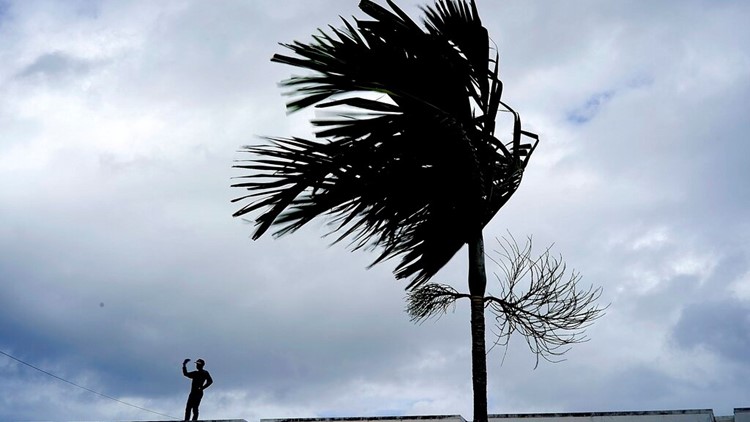
A dangerous Hurricane Dorian is closing in on the northern Bahamas, threatening to batter the normally idyllic islands with fierce winds, pounding waves and torrential rain.
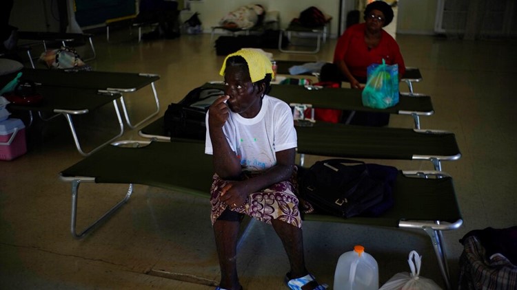
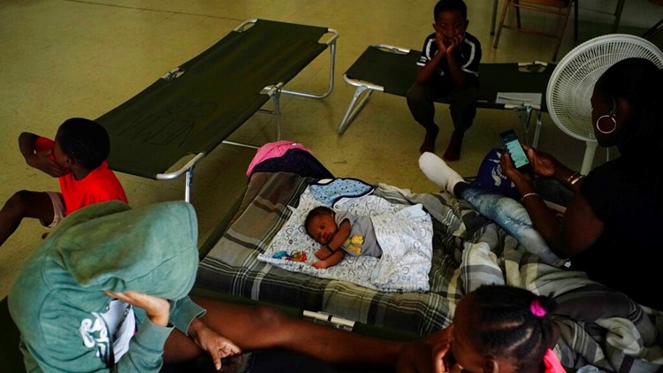
Tourist hotels closed, residents boarded up homes and officials hired boats to move people from low-lying areas to bigger islands as the powerful Category 4 hurricane approached. Many are hunkered down in schools, churches and other shelters awaiting the storm's dreaded arrival later Sunday.
Meanwhile, millions of U.S. coastal dwellers from Florida to the Carolinas are keeping a wary eye on Dorian's approach. Forecasters say many computer models indicate the storm is expected to veer sharply northeastward after passing the Bahamas and track up the Southeast seaboard, raising the risks of damaging winds and deadly flooding even if there's no direct U.S. landfall.
___
For AP's complete coverage of the hurricane: https://apnews.com/Hurricanes