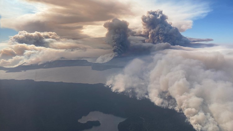
LANE COUNTY, Ore. — The Cedar Creek Fire, one of multiple wildfires burning in Oregon, covered roughly 144 square miles (92,548 acres) as of Tuesday morning with no containment, according to the latest update by fire officials.
The fire exploded in size and volatility over Friday and Saturday, driven by strong winds from the east. Cooler weather on Sunday helped firefighters make progress on the west side of the fire.
The fire is located about 60 miles east of Eugene in the Willamette and Deschutes national forests, near the town of Oakridge. The area of the fire is more than two times the size of the city of Eugene.
Smoke from the fire shifted Friday night, with east winds pushing the smoke plume northwest, causing hazy skies for northwest Oregon and southwest Washington.
The wildfire was sparked by lightning about 15 miles east of Oakridge, Ore. near Waldo Lake about five weeks ago. Friday's winds caused the fire to spread rapidly, moving toward the community of Oakridge and prompting evacuation orders for the town.
On Monday, authorities downgraded Level 3 "GO" evacuation orders to Level 2 "Be Set" for the High Prairie area, Westfir-Oakridge Road from the Westfir city limits to Roberts Road, for McFarland Road, and for Oakridge itself both north of Laurel Butte Road and east of Salmon Creek.
Oakridge west of Salmon Creek, south of Laurel Butte Road and north of the Middle Fork Willamette River, as well as the city of Westfir, were downgraded to a Level 2 "Be Set" evacuation warning on Sunday.
Officials have maintained an interactive evacuation map that will be updated as conditions and evacuation levels change. The Lane County Sheriff's Office warned that further evacuations for the communities of Oakridge, Westfir and High Prairie could happen "at any time."
There are multiple Level 3 evacuation orders in both Lane and Deschutes counties. Other areas are under Level 2 and Level 1 warnings. Sign up for emergency mobile alerts at oralert.gov. To get the latest information on evacuation levels, call the Lane County Sheriff's Office at 541-682-4150 and the Deschutes County Sheriff's Office at 541-693-6911.
The Red Cross Cascades Region opened up a shelter for evacuees of the Cedar Creek Fire. The shelter is located at the Lane Events Center at 796 West 13th Avenue in Eugene.
Nearly 1,000 firefighting personnel have been assigned to this wildfire. Because it's burning in steep, remote wilderness terrain, firefighters have primarily been using an "indirect strategy" to battle the blaze.
"This means they have been constructing firelines away from the active fire edge, along roads and trails, where they have a better chance of successfully stopping the fire," fire officials said.
A red flag warning was in effect Friday and Saturday because of hot, dry weather and strong east winds.
This week, power utilities Portland General Electric and Pacific Power initiated public safety power shutoffs that affected thousands of customers throughout western Oregon due to the dangerous fire conditions.
There are multiple other wildfires burning throughout Oregon, the largest being the Double Creek Fire, which has burned nearly 150,000 acres in northeastern Oregon's Wallowa-Whitman National Forest.